
| Type | Documents & Maps |
|---|---|
| Issued/ Not-Issued | Not-Issued |
| Conflict | World War II (1939-1945) |
| Era | 1914-1945 |
| Country/ Organization | Great Britain |
| Service | Air Force |
| Theme | Militaria |
| Country of Origin | United Kingdom |
| Modified Item | No |
Check the listing for details. England, South Sheet 11 Royal Air Force Edition WW2. Condition: Used, Made in United Kingdom. Listed at 20.45 USD. This item is a collectible World War II-era Royal Air Force (RAF) navigational map of Southern England, specifically identified as Sheet 11. Type: 1/4 Inch to One Mile Ordnance Survey Aviation Map. Context: These maps were used by RAF pilots and navigators, often during the Battle of Britain, and are labeled "For Official Use Only". Features: The map covers major southern coastal areas including Southampton, Portsmouth, and Bournemouth.
You may also like
$16.99

WWII 1943 Field Orders Nystrom's canyon lake lodge 1st Wadelene Group Rapid JOKE
$9.99

Army of the United States Rank Promotion Certificate to Sgt Tech-4th Grade 1942
$30

Vintage WWII 1941 Presidential Selective Service Certificate 1940 Draft
$8.86

Korea War Christmas Roster Menu 28th General Hospital Unit La Rochelle France
$33.48

WW2 Military Record "Court Martial & Proceedings"; Vol.1 #3; 1938
$14.99

US NAVY PICTURES 1960'S ID PAPERWORK DISCHARGE PAPERS MEDALS ALL SAME GUY
$19.99

WW2 WWII US Army Military Documents War Department Office of Chief of Engineers
$6.38

Army 1945 Documents Allotment / Deduction For Pay Acacia Life Insurance Ephenera
$10.99
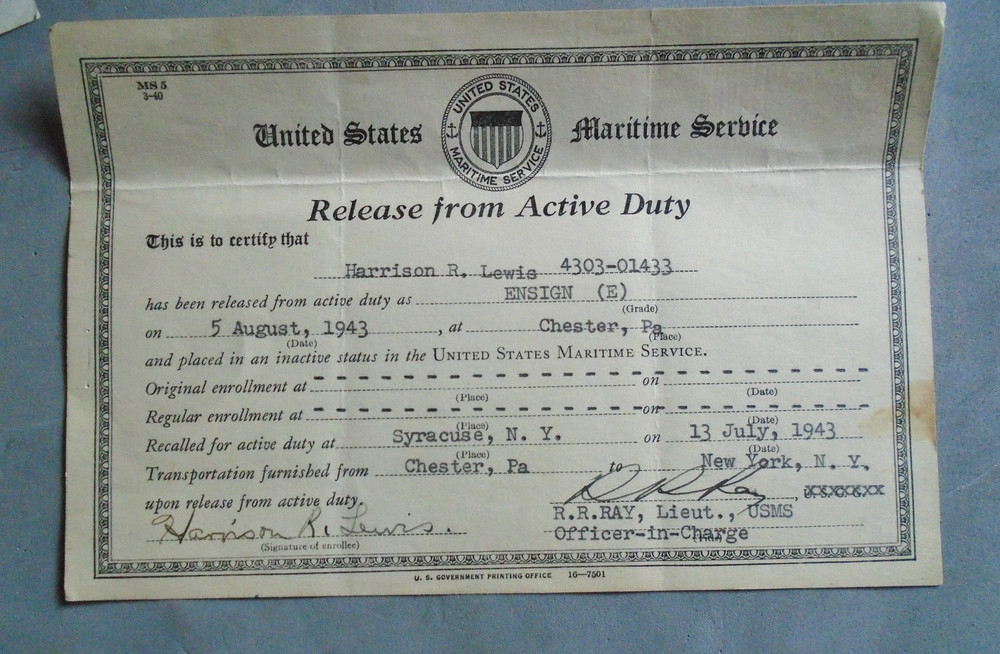
US Maritime Service Release From Active Duty certificate
$20

1941 ACAPULCO 34"x27" MAP Hydrographic Survey U.S.S. TUSCARORA 1879
$24.47

CARRIER CORPORATION Equipment Compressor Condenser for Navy Escort Vehicles 40s
$29.95

WW2 Southern Japan Map AMS L302 Vintage US Army Map Service 1945 Rare Original