| Return shipping will be paid by | Seller |
|---|---|
| All returns accepted | Returns Accepted |
| Item must be returned within | 30 Days |
| Refund will be given as | Money Back |
| Language | English |
| Manufacturer Warranty | 2 Years |
| Item Height | 7 in |
| Measurement System | Decimal & Imperial |
| Item Length | 7 in |
| Maximum Depth | 1000 m |
| Country/Region of Manufacture | United States |
| Item Width | 7 in |
| Power Source | Electric Corded |
| Sensors | GPS |
| Sport/Activity | Fishing |
| Display Resolution | 800 x 480 |
| Color | Black |
| Brand | Lowrance |
| Connectivity | NMEA 2000 |
| Indoor/Outdoor | Indoor/Outdoor |
| Display Size | 7 in |
| Features | Temperature (Water) |
| Material | Aluminum |
| Type | System with Transducer |
| Model | 000-15688-001 |
| MPN | 00015688001 |
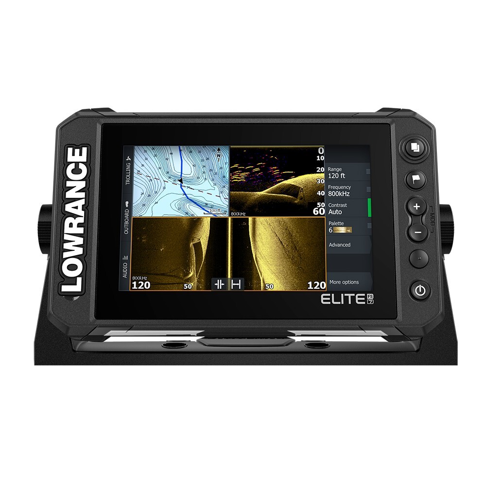
Check the listing for details. Lowrance Elite FS 7 Fish Finder Chartplotter w/ Active Imaging 3-in-1 Transducer. Color: Black, Condition: New other (see details). Listed at 899.00 USD. 7" DisplayActiveTarget™ Live Sonar ready with optional ActiveTarget™ live sonar and transducer (000-15593-001)Active Imaging™ 3-in-1 transom mount transducer includedFishReveal™Preloaded C-MAP® Contour+ with 1-foot contours on 8,900 lakesOther mapping options including C-MAP, Navionics® and moreC-MAP® Easy Routing, Navionics® Autorouting capabilityC-MAP Genesis Live onscreen mappingHigh-resolution multi-touch touchscreen Integrated wireless, NMEA 2000® and Ethernet connectivityFull touchscreen control of Power Pole® anchors and Ghost® Trolling MotorC-Map Contour+ Mapping PreloadedYou will spend more time trying to catch fish and less time trying to find them with the high-resolution detail of the C-MAP Contour+ charts built into Elite FS displays. From finding key fishing areas, like ledges, drop-offs and ditches to navigating with precision to fish-holding areas, you will have more success on the water with high-resolution 1-foot contours on 8,900 lakes.Key FeaturesCustom depth shadingEasy routing, Lowrance presentation for iconsHigh-Resolution, Bathymetric 1-foot contours on 8,900 U.S. lakesStandard navigation dataFishing POIs
You may also like